publications
publications by categories in reversed chronological order. generated by jekyll-scholar.
2026
-
 TopoGS: Planar Reconstruction via Topology-aware 3D Gaussian SplattingShanshan Pan, Jiale Chen, Yilin Liu, and Hui HuangIn European Conference on Computer Vision, 2026
Extracting structured, parametric 3D representations from raw images remains a fundamental challenge in computer vision and graphics. While recent advancements in the 3D Gaussian Splatting (3DGS) pipeline integrate planar primitives to yield compact and editable geometry, these approaches typically treat planes as isolated, discrete sets. This lack of topological connectivity hinders robust geometric reasoning, leading to fragmented reconstructions and misaligned boundaries that fall short of the precision for rigorous spatial analysis and professional design workflows. To address this, we introduce TopoGS, the first 3DGS framework to explicitly integrate both planar and topological constraints for coherent 3D reconstruction. Specifically, we extract global 2D topological relationships from multi-view image segmentations and anchor Gaussian primitives to these structural elements. This formulation enables the joint optimization of plane parameters, rendering fidelity, and topological adjacency. By enforcing strict multi-view consistency alongside these topological constraints, our method significantly mitigates geometric misalignments and produces connected, structured 3D models. Extensive evaluations on the ScanNet++ dataset demonstrate that TopoGS achieves state-of-the-art performance, providing a highly robust solution for generating accurate, topologically sound, and visually faithful scene representations.
-
 DualBrep: A Dual-Field Continuous Representation for B-rep ModellingYilin Liu, Pradeep Jayaraman, Chinthala Reddy, Xiang Xu, and Hooman ShayaniIn Proc. SIGGRAPH, 2026
Boundary Representation (B-rep) is the most commonly used data format in Computer-Aided Design (CAD) due to its analytical precision and direct support for parametric editing. However, its heterogeneous structure–continuous parametric geometry combined with discrete topological graphs–poses fundamental challenges for deep learning. Existing methods often predict the heterogeneous B-rep graph directly, using fixed-size padding or sequential tokenization to handle varying primitive counts. These approaches struggle with the combinatorial complexity of CAD models. Furthermore, the discrete, non-differentiable nature of graph data prevents end-to-end optimization of geometry and watertightness. In this work, we introduce DualBrep, a novel continuous representation that unifies B-rep geometry and topology within a fully structured Euclidean domain. DualBrep encodes a CAD model using dual scalar fields: a Signed Distance Function (SDF) representing global shape geometry, and an Unsigned Distance Field (UDF) implicitly encoding topological structure via a Voronoi partitioning of surface elements. Rather than processing these fields independently, we compress them into a single latent space. While the dual-field formulation alone provides a flexible, primitive-free segmentation signal that adapts to arbitrary face counts and surface types, the shared latent makes generation tractable. A Flow Matching model can sample geometry and topology jointly from a single code, avoiding the error accumulation that plagues sequential B-rep predictors. Finally, a neural rebuilder extracts explicit B-rep models–comprising both prismatic and free-form primitives–directly from our continuous dual fields. We demonstrate that DualBrep is a robust backbone for CAD learning, achieving strong performance in point cloud reverse engineering and generative modeling via latent flow matching.
-
 B-repLer: Semantic B-rep Latent Editor using Large Language ModelsYilin Liu, Niladri Shekhar Dutt, Changjian Li, and Niloy J. MitraIn Proc. SIGGRAPH, 2026
Computer-Aided Design (CAD) models, given their compactness and precision, remain the industry standard for designing and fabricating engineering objects. However, language-guided CAD editing is still in its infancy, largely due to missing semantic connection between user commands and underlying shape geometry, a problem exacerbated by the shortage of paired text-and-edit CAD datasets. While recent Multimodal Large Language Models (mLLMs) have attempted to bridge this gap, their reliance on CAD construction history – often an expensive and hard to obtain input – severely limits their expressiveness and restricts their usage. We present B-repLer, a novel framework that directly connects natural language with editing CAD models by operating in a learned latent space. Importantly, our approach bypasses the need for construction history, enabling semantic edits on a wide range of geometries, from simple prismatic parts to complex freeform shapes defined by B-Spline surfaces. To facilitate this research, we introduce BrepEDIT-240K, the first large-scale dataset for this task. We demonstrate how this paired dataset can be automatically generated, (user) validated, and scaled by leveraging existing CAD tools, in conjunction with mLLMs, to create the required paired data without relying on any external annotations. Our results demonstrate that B-repLer can accurately perform complex edits on complex CAD shapes, even when the input edit specifications are high-level and ambiguous to interpret, consistently producing valid, high-quality CAD outputs enabling a class of text-guided edits not previously possible.
-
 Learning to Solve PDEs on Neural Shape RepresentationsLilian Welschinger, Yilin Liu, Zican Wang, and Niloy MitraIn Proc. CVPR, 2026
Solving partial differential equations (PDEs) on shapes underpins many shape analysis and engineering tasks; yet, prevailing PDE solvers operate on polygonal/triangle meshes while modern 3D assets increasingly live as neural representations. This mismatch leaves no suitable method to solve surface PDEs directly within the neural domain, forcing explicit mesh extraction or per-instance residual training, preventing end-to-end workflows. We present a novel, mesh-free formulation that learns a local update operator conditioned on neural (local) shape attributes, enabling surface PDEs to be solved directly where the (neural) data lives. The operator integrates naturally with prevalent neural surface representations, is trained once on a single representative shape, and generalizes across shape and topology variations, enabling accurate, fast inference without explicit meshing or per-instance optimization while preserving differentiability. Across analytic benchmarks (heat equation and Poisson solve on sphere) and real neural assets across different representations, our method slightly outperforms CPM while remaining reasonably close to FEM, and, to our knowledge, delivers the first end-to-end pipeline that solves surface PDEs on both neural and classical surface representations.
-
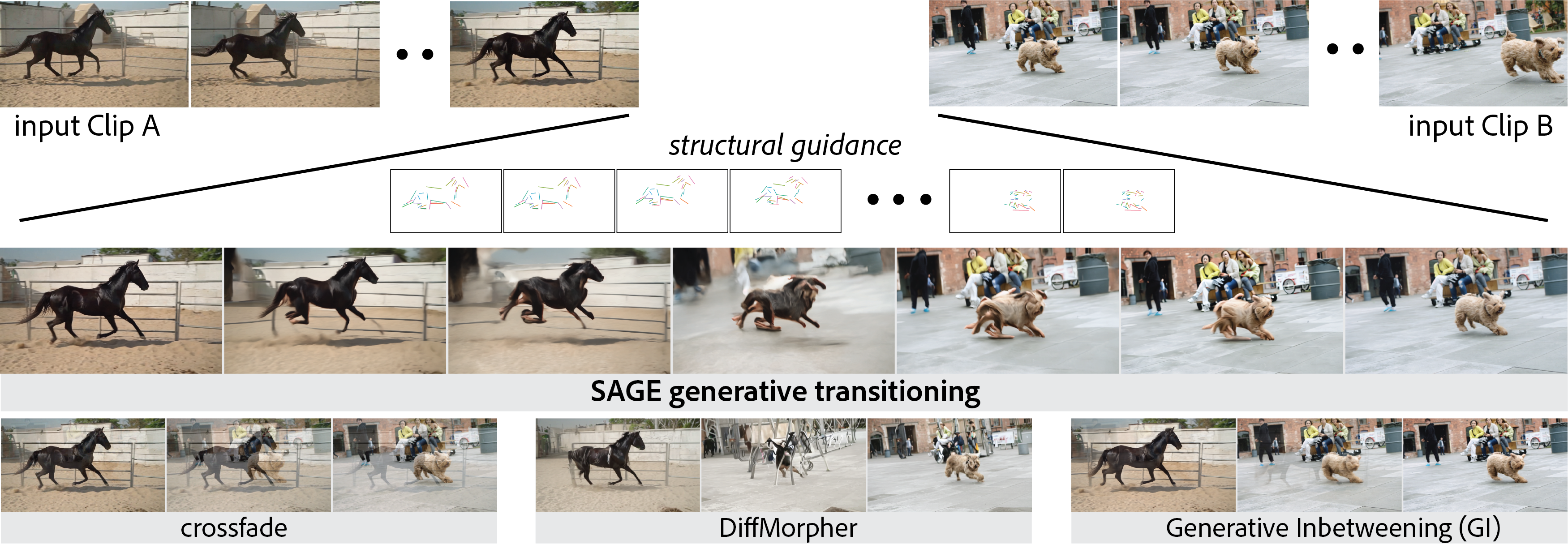 SAGE: Structure-Aware Generative Video Transitions between Diverse ClipsMia Kan, Yilin Liu, and Niloy MitraIn Eurographics, 2026
Video transitions aim to synthesize intermediate frames between two clips, but naive approaches such as linear blending introduce artifacts that limit professional use or break temporal coherence. Traditional techniques (cross-fades, morphing, frame interpolation) and recent generative inbetweening methods can produce high-quality plausible intermediates, but they struggle with bridging diverse clips involving large temporal gaps or significant semantic differences, leaving a gap for content-aware and visually coherent transitions. We address this challenge by drawing on artistic workflows, distilling strategies such as aligning silhouettes and interpolating salient features to preserve structure and perceptual continuity. Building on this, we propose SAGE (Structure-Aware Generative vidEo transitions) as a zeroshot approach that combines structural guidance, provided via line maps and motion flow, with generative synthesis, enabling smooth, semantically consistent transitions without fine-tuning. Extensive experiments and comparison with current alternatives, namely [FILM, TVG, DiffMorpher, VACE, GI], demonstrate that SAGE outperforms both classical and generative baselines on quantitative metrics and user studies for producing transitions between diverse clips.
2025
-
 AutoBrep: Autoregressive B-Rep Generation with Unified Topology and GeometryXiang Xu, Pradeep Kumar Jayaraman, Joseph G. Lambourne, Yilin Liu, Durvesh Malpure, and Pete MeltzerIn Proc. SIGGRAPH Asia, 2025
AutoBrep is a decoder-only Transformer model that autoregressively generates B-Rep geometry and topology tokens following a BFS order of the B-Rep topology graph. Geometric information is tokenized as bounding boxes paired with encoded UV-grid shape codes. Topological structure is represented via a special face identifier that maps face–edge adjacencies into reference tokens.
-
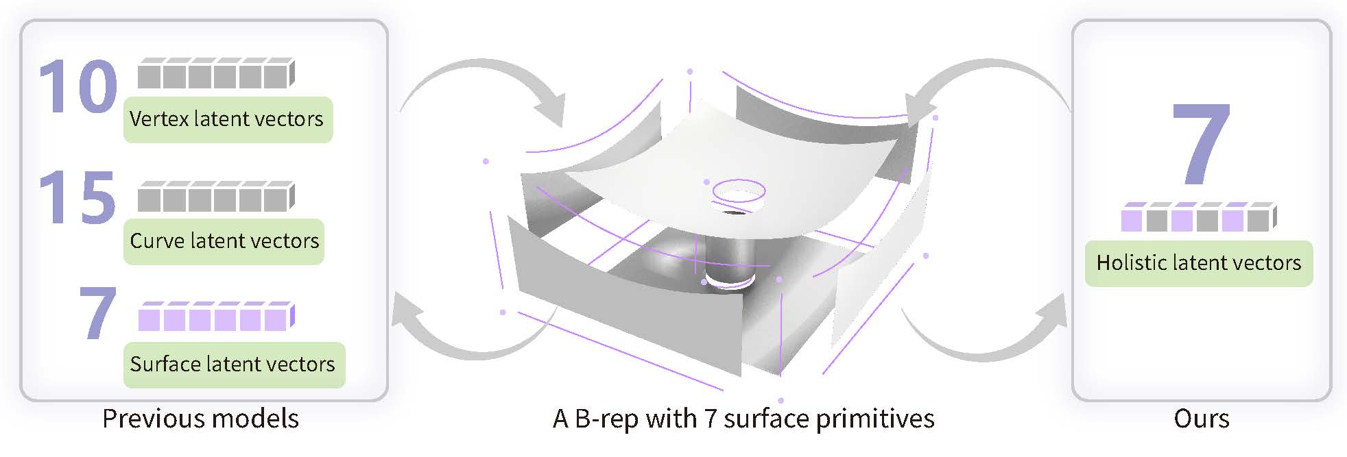 HoLa: B-Rep Generation using a Holistic Latent RepresentationYilin Liu, Duoteng Xu, Xingyao Yu, Xiang Xu, Daniel Cohen-Or, Hao Zhang, and Hui HuangACM Transactions on Graphics (SIGGRAPH), 2025
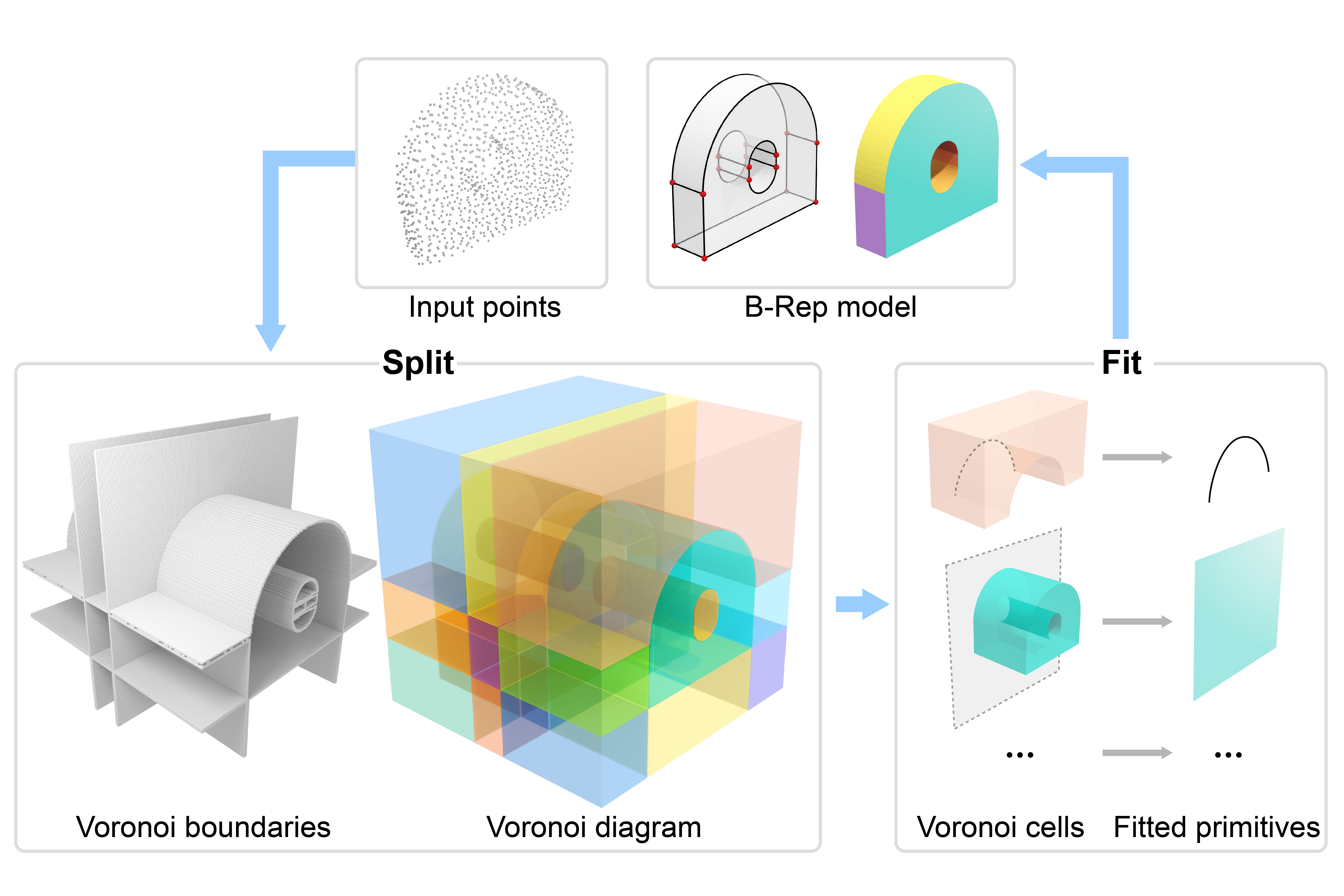
We introduce a novel method for acquiring boundary representations (B-Reps) of 3D CAD models which involves a two-step process: it first applies a spatial partitioning, referred to as the “split“, followed by a “fit“ operation to derive a single primitive within each partition. Specifically, our partitioning aims to produce the classical Voronoi diagram of the set of ground-truth (GT) B-Rep primitives. In contrast to prior B-Rep constructions which were bottom-up, either via direct primitive fitting or point clustering, our Split-and-Fit approach is top-down and structure-aware, since a Voronoi partition explicitly reveals both the number of and the connections between the primitives. We design a neural network to predict the Voronoi diagram from an input point cloud or distance field via a binary classification. We show that our network, coined NVD-Net for neural Voronoi diagrams, can effectively learn Voronoi partitions for CAD models from training data and exhibits superior generalization capabilities. Extensive experiments and evaluation demonstrate that the resulting B-Reps, consisting of parametric surfaces, curves, and vertices, are more plausible than those obtained by existing alternatives, with significant improvements in reconstruction quality. Code will be released on https://github.com/yilinliu77/NVDNet.
-
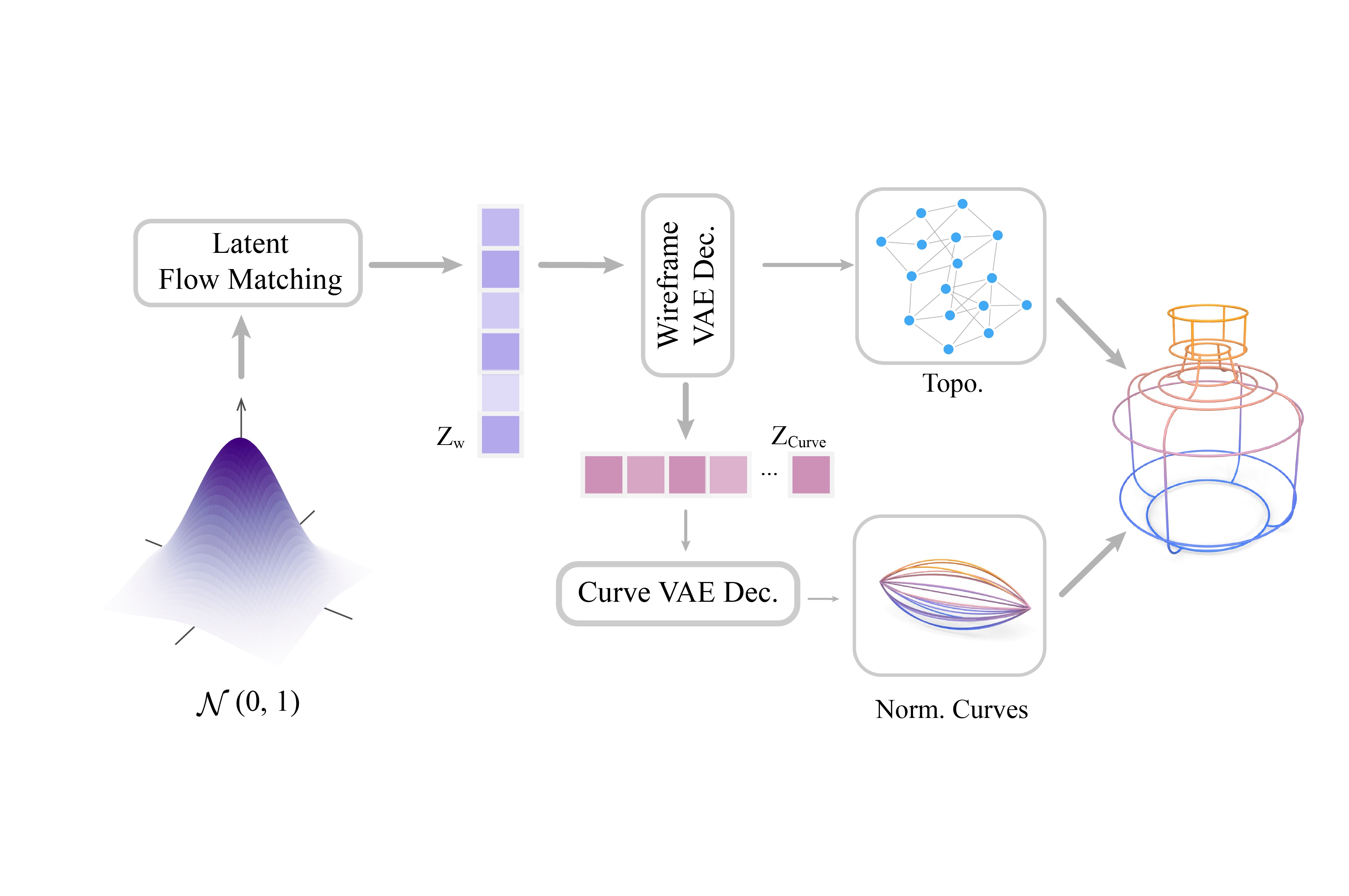 CLR-Wire: Towards Continuous Latent Representations for 3D Curve Wireframe GenerationXueqi Ma, Yilin Liu, Tianlong Gao, Qirui Huang, and Hui HuangIn Proc. SIGGRAPH, 2025
We introduce CLR-Wire, a novel framework for 3D curve-based wireframe generation that integrates geometry and topology into a unified Continuous Latent Representation. Unlike conventional methods that decouple vertices, edges, and faces, CLR-Wire encodes curves as Neural Parametric Curves along with their topological connectivity into a continuous and fixed-length latent space using an attention-driven variational autoencoder (VAE). This unified approach facilitates joint learning and generation of both geometry and topology. To generate wireframes, we employ a flow matching model to progressively map Gaussian noise to these latents, which are subsequently decoded into complete 3D wireframes. Our method provides fine-grained modeling of complex shapes and irregular topologies, and supports both unconditional generation and generation conditioned on point cloud or image inputs. Experimental results demonstrate that, compared with state-of-the-art generative approaches, our method achieves substantial improvements in accuracy, novelty, and diversity, offering an efficient and comprehensive solution for CAD design, geometric reconstruction, and 3D content creation.
2024
-
 Generating 3D House Wireframes with SemanticsXueqi Ma, Yilin Liu, Wenjun Zhou, Ruowei Wang, and Hui HuangEuropean Conference on Computer Vision, 2024
We present a new approach for generating 3D house wireframes with semantic enrichment using an autoregressive model. Unlike conventional generative models that independently process vertices, edges, and faces, our approach employs a unified wire-based representation for improved coherence in learning 3D wireframe structures. By re-ordering wire sequences based on semantic meanings, we facilitate seamless semantic integration during sequence generation. Our two-phase technique merges a graph-based autoencoder with a transformer-based decoder to learn latent geometric tokens and generate semantic-aware wireframes. Through iterative prediction and decoding during inference, our model produces detailed wireframes that can be easily segmented into distinct components, such as walls, roofs, and rooms, reflecting the semantic essence of the shape. Empirical results on a comprehensive house dataset validate the superior accuracy, novelty, and semantic fidelity of our model compared to existing generative models. More results and details can be found on https://vcc.tech/research/2024/3DWire.
-
 Split-and-Fit: Learning B-Reps via Structure-Aware Voronoi PartitioningYilin Liu, Jiale Chen, Shanshan Pan, Daniel Cohen-Or, Hao Zhang, and Hui HuangACM Trans. on Graphics (Proc. of SIGGRAPH), 2024
We introduce a novel method for acquiring boundary representations (B-Reps) of 3D CAD models which involves a two-step process: it first applies a spatial partitioning, referred to as the “split“, followed by a “fit“ operation to derive a single primitive within each partition. Specifically, our partitioning aims to produce the classical Voronoi diagram of the set of ground-truth (GT) B-Rep primitives. In contrast to prior B-Rep constructions which were bottom-up, either via direct primitive fitting or point clustering, our Split-and-Fit approach is top-down and structure-aware, since a Voronoi partition explicitly reveals both the number of and the connections between the primitives. We design a neural network to predict the Voronoi diagram from an input point cloud or distance field via a binary classification. We show that our network, coined NVD-Net for neural Voronoi diagrams, can effectively learn Voronoi partitions for CAD models from training data and exhibits superior generalization capabilities. Extensive experiments and evaluation demonstrate that the resulting B-Reps, consisting of parametric surfaces, curves, and vertices, are more plausible than those obtained by existing alternatives, with significant improvements in reconstruction quality. Code will be released on https://github.com/yilinliu77/NVDNet.
2022
-
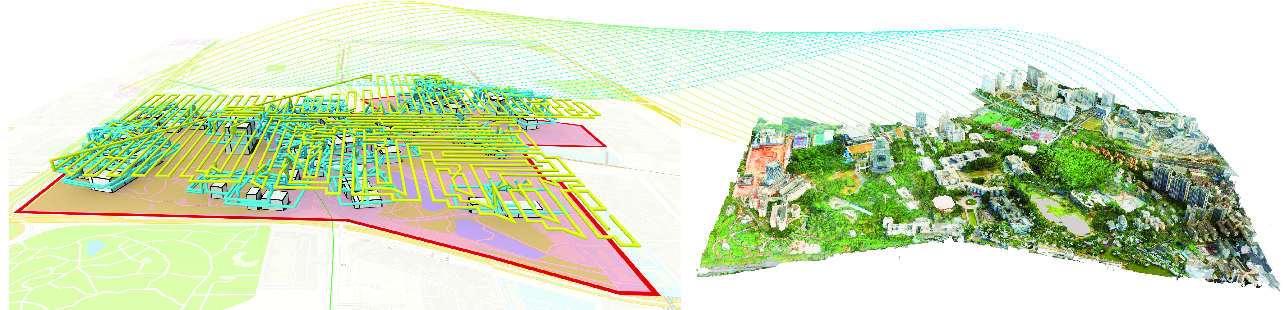
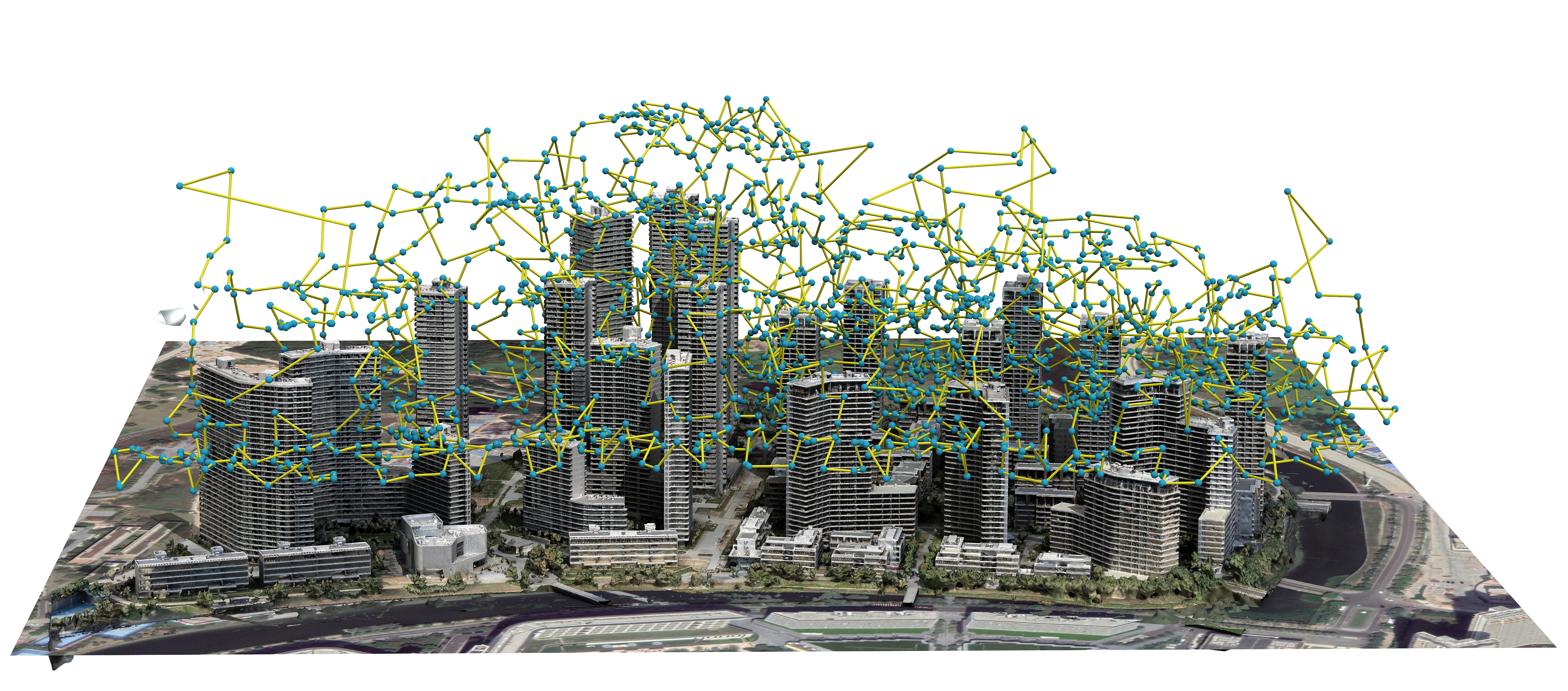
 Learning Reconstructability for Drone Aerial Path PlanningYilin Liu, Liqiang Lin, Yue Hu, Ke Xie, Chi-Wing Fu, Hao Zhang, and Hui HuangACM Trans. on Graphics (Proc. of SIGGRAPH Asia), 2022
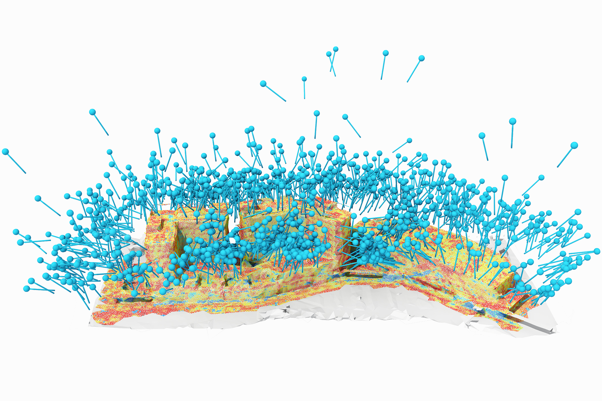
We introduce the first learning-based reconstructability predictor to improve view and path planning for large-scale 3D urban scene acquisition using unmanned drones. In contrast to previous heuristic approaches, our method learns a model that explicitly predicts how well a 3D urban scene will be reconstructed from a set of viewpoints. To make such a model trainable and simultaneously applicable to drone path planning, we simulate the proxy-based 3D scene reconstruction during training to set up the prediction. Specifically, the neural network we design is trained to predict the scene reconstructability as a function of the proxy geometry, a set of viewpoints, and optionally a series of scene images acquired in flight. To reconstruct a new urban scene, we first build the 3D scene proxy, then rely on the predicted reconstruction quality and uncertainty measures by our network, based off of the proxy geometry, to guide the drone path planning. We demonstrate that our data-driven reconstructability predictions are more closely correlated to the true reconstruction quality than prior heuristic measures. Further, our learned predictor can be easily integrated into existing path planners to yield improvements. Finally, we devise a new iterative view planning framework, based on the learned reconstructability, and show superior performance of the new planner when reconstructing both synthetic and real scenes.
-
 Capturing, Reconstructing, and Simulating: the UrbanScene3D DatasetLiqiang Lin, Yilin Liu, Yue Hu, Xingguang Yan, Ke Xie, and Hui HuangEuropean Conference on Computer Vision, 2022
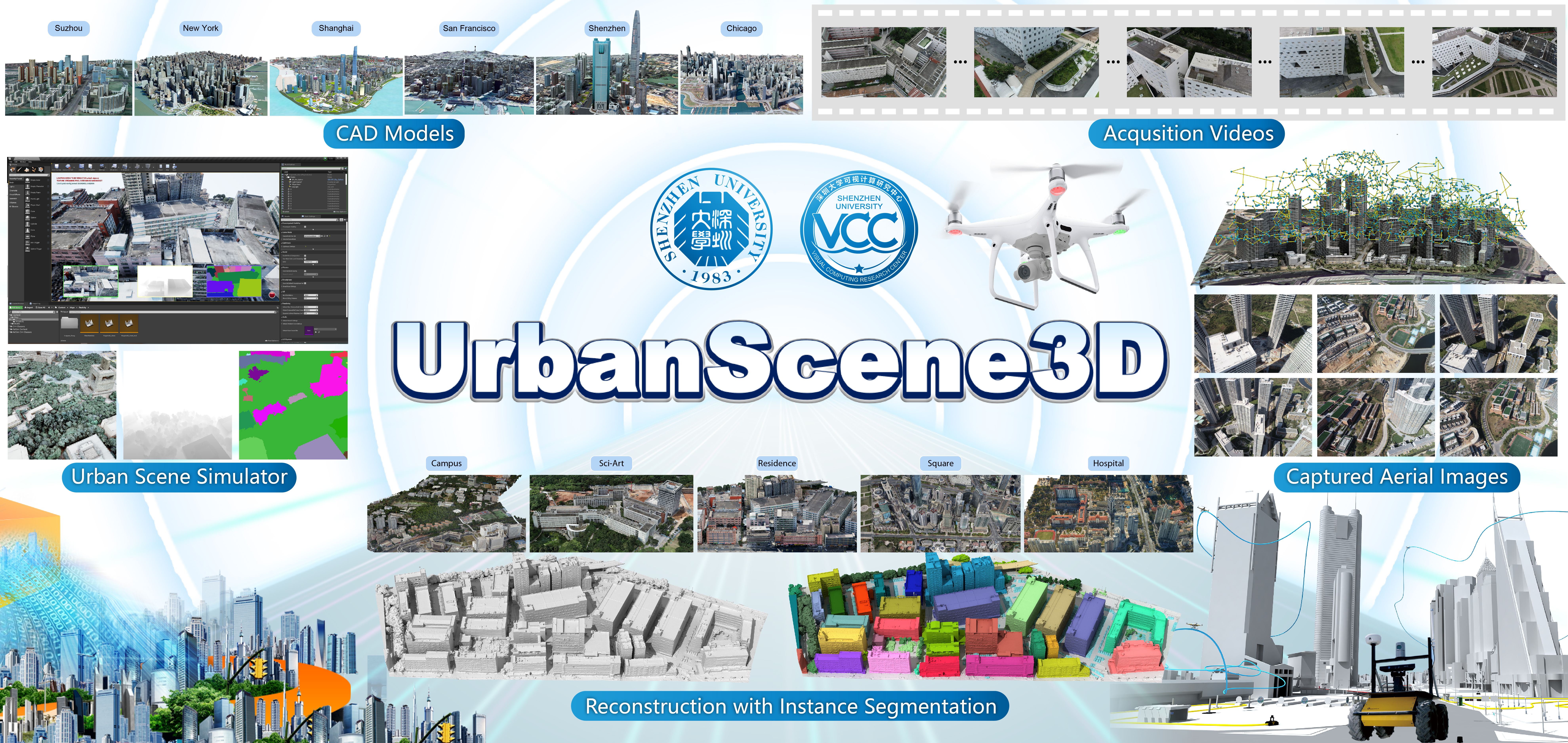
We present UrbanScene3D, a large-scale data platform for research of urban scene perception and reconstruction. UrbanScene3D contains over 128k high-resolution images covering 16 scenes including large-scale real urban regions and synthetic cities with 136 km^2 area in total. The dataset also contains high-precision LiDAR scans and hundreds of image sets with different observation patterns, which provide a comprehensive benchmark to design and evaluate aerial path planning and 3D reconstruction algorithms. In addition, the dataset, which is built on Unreal Engine and Airsim simulator together with the manually annotated unique instance label for each building in the dataset, enables the generation of all kinds of data, e.g., 2D depth maps, 2D/3D bounding boxes, and 3D point cloud/mesh segmentations, etc. The simulator with physical engine and lighting system not only produce variety of data but also enable users to simulate cars or drones in the proposed urban environment for future research.
2021
-
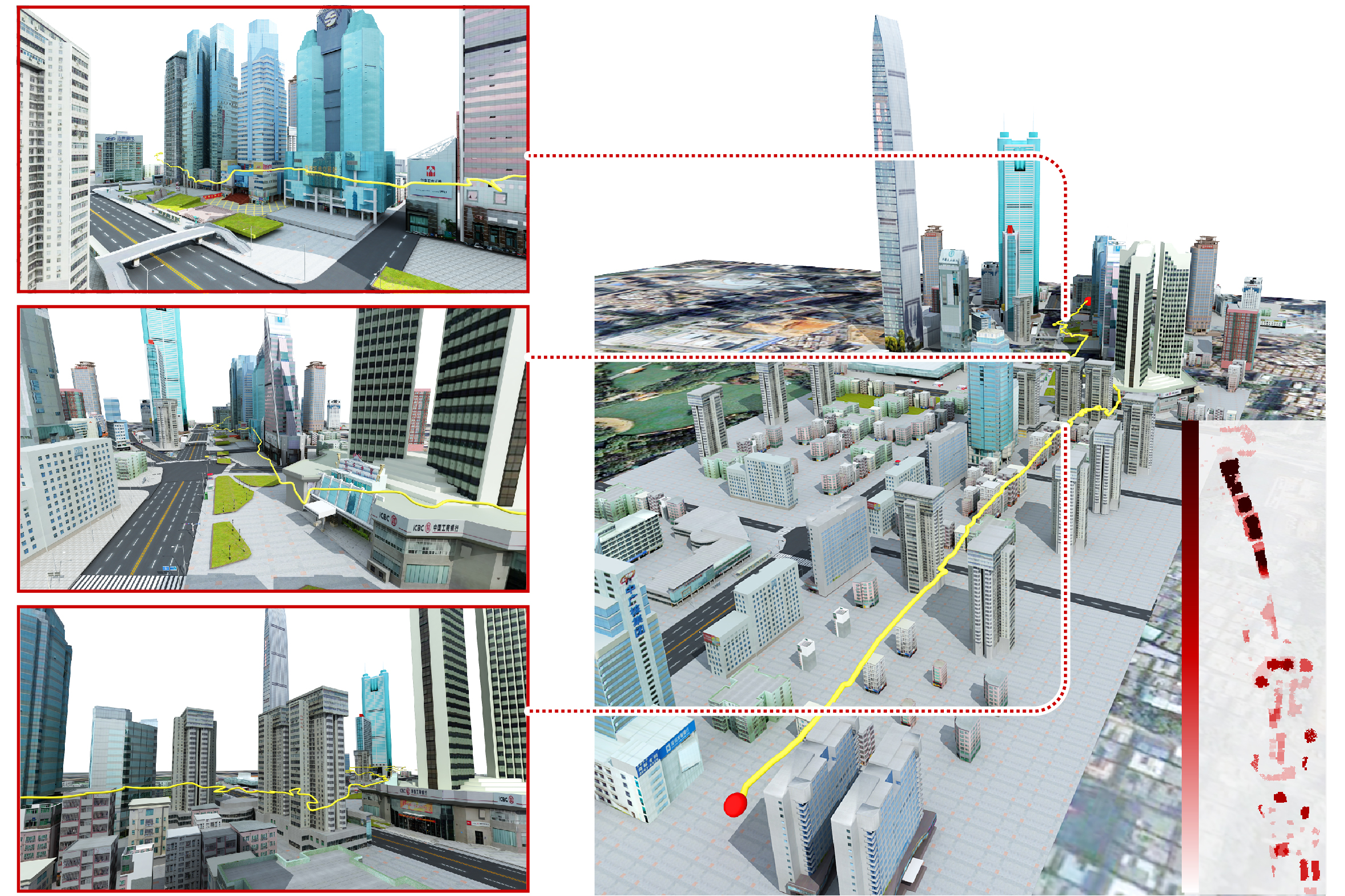
 Aerial Path Planning for Online Real-Time Exploration and Offline High-Quality Reconstruction of Large-Scale Urban ScenesYilin Liu, Ruiqi Cui, Ke Xie, Minglun Gong, and Hui HuangACM Trans. on Graphics (Proc. of SIGGRAPH Asia), 2021
Existing approaches have shown that, through carefully planning flight trajectories, images captured by Unmanned Aerial Vehicles (UAVs) can be used to reconstruct high-quality 3D models for real environments. These approaches greatly simplify and cut the cost of large-scale urban scene reconstruction. However, to properly capture height discontinuities in urban scenes, all state-of-the-art methods require prior knowledge on scene geometry and hence, additional prepossessing steps are needed before performing the actual image acquisition flights. To address this limitation and to make urban modeling techniques even more accessible, we present a real-time explore-and-reconstruct planning algorithm that does not require any prior knowledge for the scenes. Using only captured 2D images, we estimate 3D bounding boxes for buildings on-the-fly and use them to guide online path planning for both scene exploration and building observation. Experimental results demonstrate that the aerial paths planned by our algorithm in realtime for unknown environments support reconstructing 3D models with comparable qualities and lead to shorter flight air time.
- UrbanScene3D: A Large Scale Urban Scene Dataset and SimulatorYilin Liu, Fuyou Xue, and Hui HuangGraphic Open Source Dataset Award, 2021
-
 VGF-Net: Visual-Geometric Fusion Learning for Simultaneous Drone Navigation and Height MappingYilin Liu, Ke Xie, and Hui HuangGraphical Models, 2021
The drone navigation requires the comprehensive understanding of both visual and geometric information in the 3D world. In this paper, we present a Visual-Geometric Fusion Network (VGF-Net), a deep network for the fusion analysis of visual/geometric data and the construction of 2.5D height maps for simultaneous drone navigation in novel environments. Given an initial rough height map and a sequence of RGB images, our VGF-Net extracts the visual information of the scene, along with a sparse set of 3D keypoints that capture the geometric relationship between objects in the scene. Driven by the data, VGF-Net adaptively fuses visual and geometric information, forming a unified Visual-Geometric Representation. This representation is fed to a new Directional Attention Model (DAM), which helps enhance the visual-geometric object relationship and propagates the informative data to dynamically refine the height map and the corresponding keypoints. An entire end-to-end information fusion and mapping system is formed, demonstrating remarkable robustness and high accuracy on the autonomous drone navigation across complex indoor and large-scale outdoor scenes.
2020
-
 Offsite Aerial Path Planning for Efficient Urban Scene ReconstructionXiaohui Zhou, Ke Xie, Kai Huang, Yilin Liu, Yang Zhou, Minglun Gong, and Hui HuangACM Trans. on Graphics (Proc. of SIGGRAPH Asia), 2020
With rapid development in UAV technologies, it is now possible to reconstruct large-scale outdoor scenes using only images captured by low-cost drones. The problem, however, becomes how to plan the aerial path for a drone to capture images so that two conflicting goals are optimized: maximizing the reconstruction quality and minimizing mid-air image acquisition effort. Existing approaches either resort to pre-defined dense and thus inefficient view sampling strategy, or plan the path adaptively but require two onsite flight passes and intensive computation in-between. Hence, using these methods to capture and reconstruct large-scale scenes can be tedious. In this paper, we present an adaptive aerial path planning algorithm that can be done before the site visit. Using only a 2D map and a satellite image of the to-be-reconstructed area, we first compute a coarse 2.5D model for the scene based on the relationship between buildings and their shadows. A novel Max-Min optimization is then proposed to select a minimal set of viewpoints that maximizes the reconstructability under the the same number of viewpoints. Experimental results on benchmark show that our planning approach can effectively reduce the number of viewpoints needed than the previous state-of-the-art method, while maintaining comparable reconstruction quality. Since no field computation or a second visit is needed, and the view number is also minimized, our approach significantly reduces the time required in the field as well as the off-line computation cost for multi-view stereo reconstruction, making it possible to reconstruct a large-scale urban scene in a short time with moderate effort.